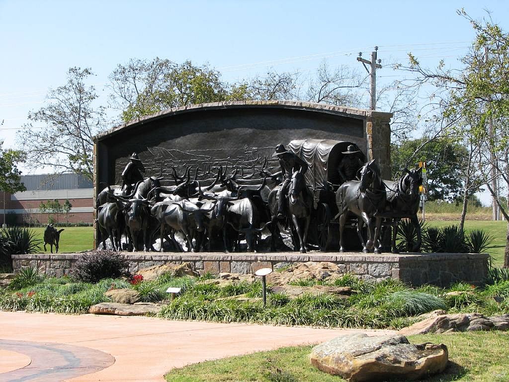
Brief HistoryDuncan, Oklahoma, is located 80 miles southwest of Oklahoma City in Stephens County on U.S. Highway 81, which parallels the Old Chisholm Trail. Between 1867 and 1876, 3 million head of Texas Longhorn cattle were driven on the trail from far south Texas, across Indian territory into Kansas where the railroads were located, ready and waiting to ship the cattle to a beef hungry nation.
The town of Duncan and our chapter are named after the founder of our town, William Duncan, who was born in Scotland in 1843. He came to America in his early 20s. Between 1870 and 1873 he and his family moved to Indian Territory and he opened a tailor shop on Cow Creek near the present site of Duncan.
|
|
William Duncan's first wife died and he married a Chickasaw Indian, therefore giving him a head right to Indian land. He heard the railroad was coming and learned the survey would cross his land. He moved his store and family to the railroad site. He set out a new town, lots were leased to the newcomers and the town of Duncan was born in 1892.
Until March, 1921, Duncan was primarily an agricultural town. Then the oil industry was brought to town by Erle P. Halliburton, a consulting engineer with progressive ideas about cementing wells. Mr. Halliburton started the company that is now Halliburton Services, the largest company of its kind in the world today.

|
Duncan Chapter, NSDAR, BeginningsThe Duncan Chapter, NSDAR, was organized in Duncan, Oklahoma, on April 16, 1927, with 12 members. Organizing chapter regent was Frankie Jones Williamson. There have been over 40 subsequent regents with some serving two or three terms.
Charlotte Jenkins was instrumental in starting the Stephens County Historical Museum and set up the Charlotte Jenkins room furnished with fine antique furniture where the Duncan Chapter, NSDAR, held many meetings.
|
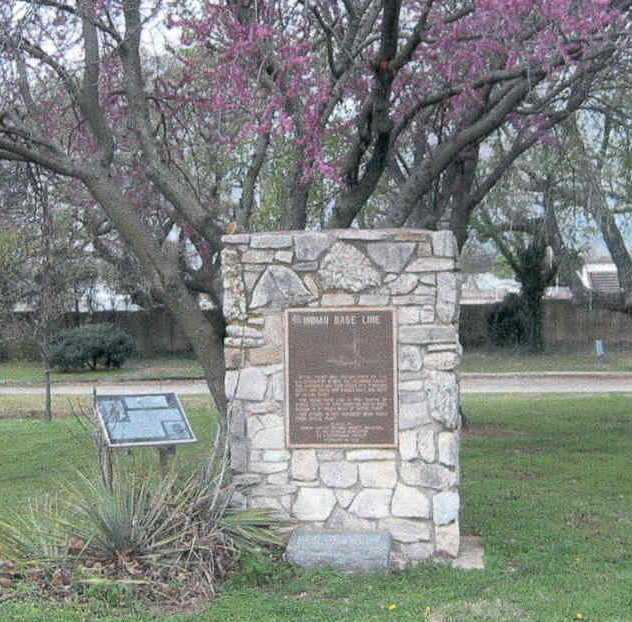
Indian Base Line Monument
|
On February 22, 1974, the Duncan Chapter, NSDAR, placed a stone monument with a bronze plaque as a Bicentennial Project in Duncan Memorial Park. The plaque reads:
"Initial Point was established by the U.S. Government in 1870. All Oklahoma except the Panhandle was then divided into Townships north and south and ranges east and west of Initial Point. The "Indian Base Line" is two tenths of a mile south of this point on Beech road. Duncan is 41 miles west of Initial Point. The stones in this monument were taken from "Initial Point." Placed by Duncan Chapter National Society Daughters of the American revolution as a Bicentennial Project, February 22, 1974." Mrs. Ruth Ann Bush Dunlap was Regent and Chairman of the Bicentennial Project. "Initial Point" is the most important U.S. Geodetic survey mark for all of Oklahoma except the Panhandle. It is used as far north as South Dakota and by southwestern states. |
|
In addition to being named after William Duncan, the chapter voted in 2009 to add "Indian Territory" to our name to incorporate the complete history of our community in our chapter's name -- Duncan Indian Territory Chapter, NSDAR.
|
Top photo: Duncan, OK : At The Chisholm Trail Heritage Center photo, picture, image (Oklahoma) at city-data.com
Middle photo: Exploring Oklahoma History - Stephens Co. Historical Museum (Duncan Armory) (blogoklahoma.us) Bottom photo: Chapter submitted |
